
Drive south from Bryce for an hour and a half and the plateau country gives way to something older and redder. Kanab sits at the foot of the Vermilion Cliffs, the second step of the Grand Staircase, at about 4,900 feet (1,500 m) of elevation, a small town at the junction of two highways with an outsized reputation. It is the base for some of the most sought-after ground in the Southwest: the striped sandstone of the Wave, the deep slot of Buckskin Gulch, the swirled domes of White Pocket. Much of that ground is rationed by permit and lottery, which confuses first-time visitors. This is our attempt to make the rules plain, in general terms, and to point out how much there is to do even without a winning ticket.
Table of Contents
Getting there and the lie of the land
Kanab is roughly 77 miles (124 km) from Bryce Canyon via Highway 12 and US-89, about an hour and a half of easy driving through Long Valley. From Kanab, US-89 continues east toward Page and Lake Powell, and US-89A runs south across the Arizona line toward Jacob Lake and the North Rim of the Grand Canyon. Between those two highways, straddling the state line, lies the country that concerns us: the Paria Plateau, the Coyote Buttes and the long red wall of the Vermilion Cliffs themselves.
Vermilion Cliffs National Monument covers about 280,000 acres (113,000 hectares) on the Arizona side and was established in 2000. Its Utah neighbour is the Paria Canyon-Vermilion Cliffs Wilderness, managed together with it. The cliffs are also the site of a long-running programme to return California condors to the wild; birds have been released from the top of the escarpment since 1996, and with patience and binoculars you may see one soaring off the rim.
The town itself earned the nickname “Little Hollywood” for the many westerns filmed in the surrounding canyons from the 1920s to the 1970s. It is a friendly, practical place with fuel, groceries and a ranger office where permits are drawn and questions are answered, which is where every trip in this country should begin.
The Wave and Coyote Buttes North
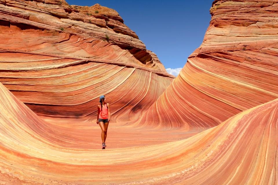
The Wave is a bowl of cross-bedded Navajo sandstone whose layers have eroded into flowing bands of red, orange and cream. It lies in an area called Coyote Buttes North, reached by a walk of about 3 miles (4.8 km) each way from a trailhead on House Rock Valley Road, a dirt road that connects the two highways south of Kanab. The walk is unmarked, across open slickrock and sand, and navigation is by map and landmarks.
Access is strictly limited to protect the fragile rock. Only a few dozen people are allowed in per day, and every one of them holds a permit won by lottery. There are two lotteries. An advance lottery is drawn online several months ahead for specific dates. A second, short-notice lottery is drawn a couple of days before each entry date, and to enter it you must be physically in the area, since the application uses your phone’s location. Both lotteries charge a small application fee, and winners pay a further per-person fee. Odds vary with the season but are long; a single application in spring or fall typically has well under a ten percent chance. Plan a visit that does not depend on winning, and treat a ticket as a gift.
Coyote Buttes South and White Pocket
South of the Wave, Coyote Buttes South holds similar teepee-shaped formations and striped rock, and it uses its own daily permit with better odds, partly because the road to it is far worse. Reaching the trailheads requires a genuine four-wheel-drive vehicle with high clearance and experience in deep sand; a great many rental cars have been dug out of that road by other people’s shovels.
White Pocket, further along the same sandy tracks, requires no permit at all. It is a compact area of swirled, brain-like white and red rock, perhaps the strangest surface we have ever walked on, and it can be explored freely for an afternoon. The catch is the approach: 30 or so miles (48 km) of sand and rock from the highway that should not be attempted by anyone unsure of their vehicle or their skills. Guided trips run from Kanab for those who would rather leave the driving to someone with a winch.
Buckskin Gulch and the Paria
For a taste of slot canyon without a lottery, the Wire Pass trailhead on House Rock Valley Road, about 8 miles (13 km) of dirt off US-89, is the answer. A day-use permit is required, but it is bought at the trailhead without a draw. From the parking area, an easy walk of about 1.7 miles (2.7 km) down a sandy wash leads into a short, tight slot that opens after a few hundred yards into Buckskin Gulch, one of the longest and deepest slot canyons in the world. Buckskin runs for around 13 miles (21 km) with walls up to 400 feet (120 m) high and, in places, only a few feet apart. Day walkers wander a mile or two into the gulch and return; the through-hike to the Paria River is an overnight expedition governed by a separate permit system with its own quota.
The same rule applies here as in every slot: if there is any chance of rain in the region, do not go in. Buckskin has drowned people. The ranger office posts a flood potential each morning, and we treat anything above low as a day for the open desert instead.
Things you can do with no permit at all
- The Toadstools, a short 1.5 mile (2.4 km) round-trip walk off US-89 east of Kanab to a field of capped hoodoos, perfect near sunset.
- Coral Pink Sand Dunes, a state park about 20 miles (32 km) northwest of town, with a small entrance fee and a landscape of rose-coloured dunes against red cliffs.
- The Paria movie set area and the coloured badlands of the Paria valley, reached by a graded dirt road off US-89.
- The North Rim of the Grand Canyon, about 80 miles (129 km) south via Jacob Lake, open from mid-May to mid-October and far quieter than the South Rim.
- Zion’s east entrance, about 40 miles (64 km) west, an easy day trip for a walk to Canyon Overlook.
Seasons and sense
Kanab is lower and hotter than Bryce. Summer afternoons run past 100 F (38 C) on the sand and rock; spring and fall, from March to May and September to November, are the seasons the lotteries are most competitive for good reason. Winter is quiet, cold at night, and often clear, with occasional snow on the cliffs that melts by noon. In every season, this is country where the road, the weather and the paperwork matter as much as the scenery. Start at the ranger office, carry more water than feels sensible, tell someone where you are going, and the Vermilion Cliffs will repay you generously, ticket or no ticket.