
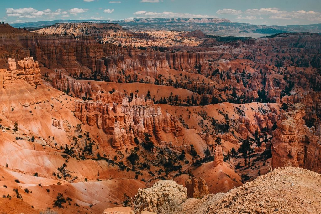
Bryce Canyon is small enough to see well in a single day, and that is exactly why it rewards a plan. The park’s main event, Bryce Amphitheater, is a bowl of pink and orange limestone spires about 3 miles (5 km) across, and its four rim viewpoints sit within a couple of miles of each other. The trick is not to drive from overlook to overlook but to walk one loop down among the hoodoos, then give the rest of the day to the rim and the scenic drive. Here is the day we would build if we had only one, starting before dawn and ending after the last light drains off the cliffs.
Table of Contents
Why the day starts at Sunrise Point
The amphitheater faces east, which settles the question of when to look at it. At first light the sun comes up over the Table Cliff Plateau and hits the hoodoos head on, lighting the whole bowl in a single wash of orange. By mid-morning the rock flattens; in the afternoon the rim casts its shadow into the spires. So we get up early. Sunrise Point stands at just over 8,000 feet (2,440 m), and it is cold up there before the sun arrives even in July: bring a jacket, a hat and something hot, and expect frost on the railings in May and September. Twenty minutes before official sunrise the sky goes violet, then the tips of the tallest hoodoos catch fire one at a time. It is the best show in the park and it costs nothing but sleep.
Parking at the point fills in high season. The park runs a free shuttle from the gateway area outside the entrance roughly from spring to autumn. Entry is by a per-vehicle fee valid for a week, or by the annual federal pass, and neither requires a reservation at the time of writing.
Down into Queens Garden
Once the light has settled we drop below the rim on the Queens Garden Trail, which leaves directly from Sunrise Point. It is the gentlest route into the amphitheater: 0.9 miles (1.4 km) one way and about 320 feet (100 m) of descent, on a wide dirt path that winds through short tunnels cut in the rock and past hoodoos you can touch. The garden itself is a cluster of spires at the bottom, named for a formation said to resemble a queen in a long gown; whether you see her or not, the setting is lovely, with ponderosa pines growing tall in the shelter of the walls.
Take the descent slowly. The surface is loose gravel over hardpan, and at this elevation even a modest grade strains lungs used to sea level.
The connector and the choice at the bottom
From the end of Queens Garden a connecting trail runs about 0.6 miles (1 km) through the bottom of the amphitheater to the foot of the Navajo Loop. This is the quiet part of the walk, in and out of shade under Douglas fir, and the place to stop for a snack. Above you is the choice: the Navajo Loop has two arms climbing back to Sunset Point. Wall Street is the famous one, a slot between sheer walls with two enormous firs growing in the bottom of it, climbing 550 feet (170 m) in a stack of switchbacks. Two Bridges is the other arm, slightly gentler, passing a pair of small natural bridges high on the wall and giving a view of Thor’s Hammer, the single most photographed hoodoo in the park, near the top.
Wall Street is closed in winter and often into spring because of ice and rockfall, so from roughly November to April Two Bridges is the only way up. In summer both are open and we go up Wall Street for the drama.
The Rim Trail back and what the loop adds up to
The top of the Navajo Loop arrives at Sunset Point, and the paved Rim Trail carries you the 0.5 miles (0.8 km) back to Sunrise Point along the very edge, with the whole amphitheater below you. The combined loop is about 2.9 miles (4.7 km) with around 600 feet (180 m) of climbing, and most people take two to three hours including stops. Done in this direction, down Queens Garden and up Navajo, it is easier on the knees and better for the view: you descend the gentle arm and climb the steep one, and the hoodoos are in front of you all the way down.
Water matters more than the distance suggests. There is none on the trail, the air is dry and the sun is strong at this altitude, and one litre (about a quart) per person is the minimum even for this short loop. Between July and early September the afternoons bring thunderstorms, sometimes with lightning on the rim; the walk is better finished by noon.
Afternoon on the scenic drive
With the loop finished and lunch eaten, the afternoon belongs to the road. The park’s only road runs 18 miles (29 km) south from the entrance to Rainbow Point at 9,115 feet (2,778 m), the highest point in the park, gaining nearly a thousand feet along the way. There are more than a dozen viewpoints; drive to the end first and stop at the overlooks on the way back, so each pull-out is on your side of the road. The ones we would not skip are:
- Rainbow Point and Yovimpa Point, at the road’s end, where the view runs over the Grand Staircase toward the Kaibab Plateau and Arizona on a clear day, and a short loop walks through bristlecone pines.
- Natural Bridge, an arch of red rock framing a green gully, right beside the road.
- Bryce Point, back near the amphitheater, for the widest single view of the hoodoos and, at nearly 8,300 feet (2,530 m), a taste of the wind that shapes them.
The whole drive with stops takes two to three hours. The road beyond the amphitheater is often closed after winter storms until it is ploughed.
Ending at Sunset Point, honestly
Sunset Point is, despite the name, not where the sun sets: it drops behind the plateau at your back, and the amphitheater slides into shadow a good while before the sky does. That said, the last hour of light is still worth standing on the rim for. The hoodoos go from orange to a deep, muted rose as the shadow climbs them, and the far cliffs of the Table Cliff Plateau, still in sun, turn the colour of embers. Inspiration Point, a short walk south along the rim and a little higher, gives a wider version of the same show with fewer people.
Then stay. Bryce sits at high altitude, far from any city, and on a moonless night the Milky Way over the amphitheater is one of the darkest skies in the country. You need nothing more than a coat and ten minutes for your eyes to adjust. The hoodoos are pale shapes in starlight, the same rock that burned orange fourteen hours earlier, and that is the whole arc of a day at Bryce.
Read next: Bryce vs Zion: How the Two Utah Parks Differ and How to Combine Them